ईंट( bricks) को दीवारों, फुटपाथ( pavements) और चिनाई( Masonry) के निर्माण में अन्य तत्वों के लिए इस्तेमाल सामग्री( material) का निर्माण होता है।
Compositions-
clay (चिकनी मिट्टी)
bearing soil(मिट्टी)
sand(रेत)
lime(चूना)
concrete materials
- निर्माण के तरीके(method of manufacturing)
आम तौर पर, ईंटों(bricks) में निम्नलिखित तत्व होते हैं-
°Silica (sand) – 50% to 60% by weight
°Alumina (clay) – 20% to 30% by weight
°Lime – 2 to 5% by weight
°Iron oxide – ≤ 7% by weight
°Magnesia – less than 1% by weight
मिट्टी से ईंटों के निर्माण की प्रक्रिया में मिट्टी की बनावट, ढलाई (molding) और फिर ईंटों को सुखाने(drying) और जला(burning)देना शामिल है।
There are four different operations are involved in the process of manufacturing of bricks(ईंटों के निर्माण की प्रक्रिया में चार अलग-अलग संचालन शामिल हैं)
☆. Preparation of clay
☆. Molding
☆. Drying
☆. Burning
- निर्माण के तरीके(method of manufacturing)
1)-Preparation of clay
Preparation of clay for bricks manufacturing is done in six steps
Preparation of clay for bricks manufacturing is done in six steps
▪Unsoiling of clay-ईंटों की तैयारी के लिए हमें शुद्ध मिट्टी की जरूरत है मिट्टी की ऊपरी परत में अशुद्धियां हो सकती हैं, इसलिए लगभग 200 मिमी की गहराई के ऊपर की परत में मिट्टी को फेंक दिया जाता है।
▪Digging(खुदाई)- शीर्ष परत को हटाने के बाद, मिट्टी को जमीन से खोद लिया जाता है
▪Digging(खुदाई)- शीर्ष परत को हटाने के बाद, मिट्टी को जमीन से खोद लिया जाता है

▪Cleaning- इस चरण में, मिट्टी को पत्थर, सब्जी पदार्थ आदि से साफ किया जाता है
▪Weathering- साफ़ मिट्टी को नरम करने के लिए वातावरण के संपर्क में 3 से 4 सप्ताह या पूर्ण बरसात का मौसम में आमतौर पर, बड़ी परियोजनाओं के लिए बरसात के मौसम से पहले मिट्टी को खोदा जाता है
▪Blending- अगर हम मिट्टी के किसी भी घटक को जोड़ना चाहते हैं, तो इस अवस्था में मिट्टी को ढीली करके और उस पर घटक को फैलाने के लिए जोड़ा जा सकता है फिर हाथ में मिट्टी का छोटा सा हिस्सा लें और ऊर्ध्वाधर दिशा (Vertical direction) में ऊपर और नीचे ट्यूनिंग(Tuning) किया जाता है। इस प्रक्रिया को मिट्टी का सम्मिश्रण(blending of soil) कहा जाता है
▪Tempering- इस चरण में, पानी को मिट्टी में जोड़ा जाता है और दबाया जाता है या मिलाया जाता है। दबंग मवेशियों( Dabang cattle) या छोटे पैमाने पर परियोजनाओं के लिए पुरुषों के पैरों के द्वारा किया जाता है पग( Foot) मिल बड़े पैमाने पर परियोजनाओं के लिए चक्की के रूप में उपयोग किया जाता है। इसलिए, मिट्टी प्लास्टिक की प्रकृति को प्राप्त करती है और अब यह ढलाई के लिए उपयुक्त है।

2)- Molding of clay for brick manufacturing
मोल्डिंग प्रक्रिया में, तैयार मिट्टी को ईंट के आकार (आमतौर पर आयताकार) में ढालना है। इस प्रक्रिया को परियोजना के पैमाने के अनुसार दो तरीकों से किया जा सकता है।
Hand molding ( for small scale)
Machine molding ( for large scale)

3)- Drying of raw bricks
मोल्डिंग प्रक्रिया के बाद इसमें ईंटों में कुछ नमी होती है इसलिए, सुखाने का काम किया जाना चाहिए अन्यथा वे जलते समय टूट सकते हैं। कच्ची ईंटों का सुखाना प्राकृतिक प्रक्रिया द्वारा किया जाता है
ईंटें सुखाने के लिये ढेर में रखी गई हैं एक ढेर में 8 से 10 सीढ़ियां होती हैं। इन ढेरों में ईंटों को इस तरह व्यवस्थित किया जाना चाहिए कि ईंटों के बीच में हवा का संचरण मुक्त हो।
सुखाने की अवधि 3 से 10 दिन हो सकती है। यह मौसम की स्थितियों पर निर्भर करता है
बारिश के पानी से ईंटों की रोकथाम के लिए सामान्य जमीन से सुखाने वाले गज की दूरी भी उच्च स्तर पर तैयार की जाती है।
कुछ स्थितियों में कृत्रिम सुखाने विशेष ड्रायर या गर्म गैसों के तहत अपनाया जाता है।

4)- Burning of bricks
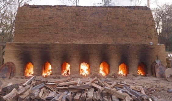
जलने की प्रक्रिया में सूखे ईंटें कुछ डिग्री तापमान तक क्लेप्स Clips(छोटे पैमाने पर) या भट्टों (बड़े पैमाने पर) में या तो जला दी जाती हैं। इस स्तर पर, ईंटों को कठोरता और मजबूती मिलेगी, इसलिए ईंटों के निर्माण में महत्वपूर्ण चरण है। जलने के लिए आवश्यक तापमान 1100 degree centrigrate है यदि वे इस सीमा से अधिक जल गए तो वे भंगुर( Brittle) और टूटना आसान हो जाएंगे। अगर वे इस सीमा के नीचे जलाए, तो वे पूर्ण मजबूती नहीं लेंगे और वातावरण से नमी को अवशोषित करने का एक मौका मिल जता है इसलिए अच्छी ईंट की आवश्यकताओं को पूरा करने के लिए जलने को ठीक से किया जाना चाहिए।
Comments
Post a Comment